Thursday 30 October 2008
St Martin's Storm
Sunday 20 November 2005
Thursday 17 November 2005
Gale Warnings
In the days leading up to the storm, the regular sailings between Stornoway and Ullapool had already been seriously disrupted due to gales on Monday and Wednesday, and engine breakdowns on the Isle of Lewis ferry on Thursday. After the storm, the Isle of Lewis could not sail, again as a result of engine breakdown.
In all, there was huge pressure in the shape of empty shops, goods backing up in Ullapool and people in Stornoway and Ullapool wishing to go across. And if a formal gale warning is not issued until much later, there is not a lot that can be done.
My original email, sent from another email address:
Sent: 11/11/2005 12:06:19
To: "enquiries" <enquiries@metoffice.gov.uk>
Subject: Severe gales - Northwest Scotland
I'm concerned that there is no advisory out for severe gales for NW
Scotland today, even though winds are gusting up to force 9 here in
Stornoway and liable to increase later.
Could you please review?
Thanks
[signed]
--- Reply ---
From: customercentre@metoffice.gov.uk
Sent: 11 November 2005 12:40:02
Thank you for your recent email.
I can confirm that we currently have the below warnings in force for
South [sic] West Scotland:
Heavy Rain
Affecting Highland
Further spells of sometimes heavy rain are expected through the rest of
Friday and Friday night giving totals of between 25 and 40mm on already
saturated ground. The public are advised to take extra care and refer to
the latest Scottish Environment Protection Agency 'Live Flood Warning
Information.'
Issued by Met Office.
Valid from: Friday 11 November, 2005 at 09:00
Expires on: Saturday 12 November, 2005 at 09:00
Severe Gales
Affecting Eilean Siar & Highland
Southerly severe gales will develop this morning over higher ground with
gusts of 70 to 80mph, increasing up to 90mph this afternoon. Later this
afternoon and through the evening winds will veer southwest then
westerly with gusts of 70-80mph also spreading to lower levels and more
populated areas. The severe gales are expected to continue well into
Friday night. Public are advised to check for new warnings and advice
through the day.
Issued by Met Office.
Valid from: Friday 11 November, 2005 at 10:00
Expires on: Friday 11 November, 2005 at 23:00
If you have any further questions or would like us to talk you through
these please contact the Customer Centre on 0870 9000 100 where one of
our advisors will be happy to help you. The number is open 24 hours a
day, seven days a week.
Yours sincerely,
Lynn Easterbrook
Customer Centre, Met Office, FitzRoy Road, Exeter, Devon, EX1 3PB,
United Kingdom. Tel: 0870 900 0100 Fax: 0870 900 5050 Email:
customercentre@metoffice.gov.uk
Wednesday 16 November 2005
Entries from Metcheck on 11/11/05
09.48
Very wild day, pouring with rain and blowing a gale. Temperature
jumped to 13C in the last few hours, but that's purely academical.
10.29
Have a look at all the ferry cancellations up and down the westcoast. And we have no severe weather warning in force from the Met Office, only with regards to rain, not to wind.
10.41 (from Martyn, an observer in Skye)
Wet and windy here in Portree! A.D. (directed at myself) - I noticed there's no severe gale warning for us as well. Strange since I checked the charts and it's almost certainly going to get pretty wild up here during the evening and into tomorrow. Maybe they just missed us off since it's such a regular occurrence!!! No trips to the mainland then!!!!
10.53 (from an observe in Co Antrim)
Cloudy, stormy morning, but wind not too severe as yet. S 26 mph with gusts to 41 mph. Light rain within the last hour. Quite mild with current temperature 13C, minimum overnight temperature 9C. Visibility greather than 7 miles. Local forecast predicts the really strong winds will arrive by afternoon. Better locate oillamps and candles, but hope they aren't needed.
11.09 (from an observer in Inverness)
Morning all, especially to those in the West - sounds like the Minch is getting pretty lumpy and those hatches need battening down again..... I see the Met Office have issued a severe weather warning for gales for NE Scotland this morning but heavy rain for NW Scotland. Maybe they think there's not enough bad weather to go round so they're sharing it out ;)
Over here by Loch Ness it was very wet and quite windy earlier but the wind has eased. A lot of water tumbling down the burn, and drains on the A82 are getting blocked with leaves so there's some flooding. If the temperature drops those roads are going to get a wee bit slippy. Right now it's mild for November at 11C, barometer dropping fast, currently at 985mb.
11.10 own report
Weather here getting gradually worse, with spindrift being blown off the waves in the inner harbour. Ullapool ferry not marked as being cancelled, but even if it does sail TO Stornoway (due to leave at 10.30), it's very much in doubht whether the return trip at 1.45 will be on.
12.04
Hardly a ferry running on the westcoast today. Wind increasing further, with pouring rain.
12.40
Well, had to put this post in: the sun is out! Wind is now seriously picking up but at least we're having a clearance. Ferry is on its way across (Vomit Comet), but will probably not return to the mainland.
13.31 Skye observer
Just been out to get some lunch - feels much colder than earlier this morning. The rain is still coming down, but it's lighter and brighter than it was a while ago. The wind is certainly strong, however. Portree is much more sheltered than other parts of the island. It will be an interesting drive to Dunvegan this evening, should conditions deteriorate further.
BBC Radio Scotland says that conditions are set to deteriorate through the afternoon. Current gales could increase up to 90 mph during the evening and night. The rain is also set to become heavier as the depression passes to the west.
Currently, virtually all of the west coast ferries are off and restrictions are in force on the roads - the Skye Bridge is now closed to high siders with restrictions in force for all other traffic as well.
13.40
Weather has turned into showers, but the squalls seem to be worsening. During one, at about 1.15, we completely lost sight of Arnish Light, only 1.5 miles across the water. A frenzy of seaspray combined with the pouring rain to produce an almost complete white-out. Could barely see the boatsheds oon the far side of the basin, and that's only a few hundred yards. We're now definitely into storm force winds, judging by the appearance of the sea. Notcie that the winds are at galeforce nationwide; one station in East Cumbria reporting gusts of 50mph at 40 miles from the sea! Waves are thrashing over the causeway, and being carried across the width of the basin.
14.42
Continuing to be increasingly wild, with the wind edging into the top of force 10 in gusts. Another squall moving in, with me now practically losing sight of the Coastguard Station, only 150 yards away. It's wreathed in flying spray. Erm, I've gotta go out for food. It's high tide, so it's very, very bad.
15.45 Skye observer
I've just got back into the office after going to collect our reserve fuel supplies for our generator in preparation for our mains supply failing here in the office. The wind has really ratcheted up in the last half hour or so, with storm foce gusts now the norm, and a pretty strong sustained speed. The wind is strong enough to be picking the water out of the sea, and the waves in Portree Bay are pretty large now. There is aleadysome damage with broken roadsigns and lots of tree debris littering the place. It's also very windy on the roads with strong cross winds now, which are gustyleading to difficult driving conditions - max 40 mph on the main road north from Portree due to the wind pushing the car about.
Quite bad right now...
16.03 Skye observer
We have flickering lights now in the office... quite a few power drops - looks like power failure is likely. Probably debris hitting the lines. Just spoke to relatives on Waternish and it's very bad there now - Waternish is very exposed!
16.27 2nd Skye observer
Ullinish on westocast of Skye. Don't expect to have power much longer. Or indeed tiles. iT's getting very scary. My monitor is rocking on the desk. I just went to Dunvegan to collect my car and the sea state is very high with water lifted into the air and across the road. The is a 5 kV power pole out of the ground at Dunvegan, being supported by the wires. Not for long I guess!
16.25 (own report)
Just ventured out for a little while. Absolutely atrocious, waves crashing over the seafront all along the town. Wind howling past the Coastguard Station, so strong it blew the water out of a 2 inch deep puddle. Very difficult to walk at times, driving difficult as well. Our ferry is currently sheltering in Loch Erisort, 15 miles south of Stornoway. The lorries on board the freight ferry Muirneag are crashing into each other, in spite of being lashed down. She is now sheltering off Tolsta, 12 miles to the north. It was unsafe for me to walk across the causeway to Goat Island, due to the strength of the wind and the amount of water that comes crashing over.
16.31
Jim Berry, Lancashire: I only need to walk half a mile down the road to a Somerfields supermarket for food. But, as you can see from the previous post, it was a battle. Have taken pictures, but they're old-fashioned film, so they won't be available till Monday at the earliest.
16.39 1st Skye reporter
Our CEO just got back in the office after having to leave in a rush. His boat broke its mooring in the bay - lucky it's not matchwood! We also have a guy here who may get stranded - it's likely they may close the Skye Bridge if conditions persist. Power still on but intermittent drops. Very noisy inside due to the wind.
We've been told to go sharpish - as the conditions are now dangerous. Just my luck to be oncall - if you're in the West Highlands and Islands - time to stay inside and ride out this one I think.
Gusting at least storm force 11 now evenhere in relatively sheltered Portree. Will be a nice drive back to Dunvegan.
16.45 Skye reporter
Mobile phone networks have just failed here in Portree - great.
17.16 Own report
We've now got hurricane force gusts coming thourgh in amongst sustained winds that are pushing storm force. Looks like Lewis is in the low pressure centre. There is a colossal pressure gradient; Stornoway is 60 miles from Lusa (Skye), with a 10 mb pressure gradient between the two.
17.42
Barometer going through the floor now, at 969 mb. The wind sustains at force 8 - 9, with gusts force 11 - 12.
17.45
Difference between SY and Lusa has increased to 12 mb. Lights flickering here - I'll try to keep reports coming through someone else if they go off.
17.48
Ferry is just coming into port, about 4h30 late. At least she's coming in (sigh of relief). I'm still worried about poor old Muirneag, off Tolsta
18.39 Skye reporter
I've just driven from Portree back home to Dunvegan (had to pick up some stuff in case I need to stay in Portree should the mains fail) and then back to Portree and I can vouch that the weather is HORRENDOUS! The wind is abysmal, couple that with driving torrential showers and copious amounts of seaspray you can imagine what is like to drive in!!! There is debris in road as well as stones from flooding.
Anyway the power supply did fail here in Portree while I was on the road, but it's all on again now. There is no mobile phone reception at all here, and the TV and radio transmitters were offline earlier, although I can get radio again now. I did hear that parts of Skye had lost their main supply already but I'm not certain. There's plenty of Hydro pepole about, but it's too bad right now for them to do much.
The main electricity substation at Dunvegan is crawling with Hydro engineers and their equipment. Poles, transformers &c - all sat waiting for the inevitable. This substation supplies the whole of the Western Isles and also the whole of North Skye, so if it goes, big areas get blacked out. Let's hope it doesn't fail - at least the engineers are ready if it does.
The wind is gusting very strong here, even worse the further west you go as you become more exposed. The rain showers are torrential right now, with flooding on the road between Portree and Dunvegan. It's still mild as the wind has not yet veered into the west, whichis when we could see the worst conditions.
All in all it's a hellish night, not pretty at all
18.44 Skye reporter
Also the BBC are reporting that the Skye Bridge has now been closed to ALL vehicles. That's unprecedented - it only happened once before and that was in January's hurricane, which was plenty wilder than tonight. I suppose it's pretty exposed.
19.05
There is now a relative lull in the storm, with the moon peeping through the clouds. Winds have dropped back to force 7, gusts up to force 10 still quite severe. I'm sparing a thought for the observer in Skye, because Lusa is still gusting up to 67 kn, force 12. Sustained windspeeds over Western Scotland have dropped back a little. Barometer very low - but my guess is that the centre of the storm system is now passing us to the northwest, also because the wind is changing into a southwesterly rather than the sustained southerly we had before. Power still on - for as long as it lasts.
19.50
Worst of the storm appears to be over, although force 7 with gusts up to force 9 is still quite strong. Wind has dropped in Ireland as well, but down in Tiree it's still doing force 10 to 12. Benbecula is having similar windspeeds, so I guess Lewis is near the centre of the storm.
21.48
Wind has decreased to force 7 -9 and veered west.Notice that the heavy gusts have transferred over the mainland, to the east. Loch Glascarnoch, far from the sea, together with Lossiemouth had a steady force 9 with gusts of force 11 at 21.00. At Aberdeen, Lerwick and Kirkwall they have galeforce 8 with gusts of force 10. Similar at Tulloch Bridge, 70 miles from the sea, where the wind gusts at force 10; Tiree at force 11.
21.51
Patrick in Bournemouth: I've been using XCWeather as a source for weatherdata all day, but thanks anyway. Benbecula is still going strong with hurricane force gusts of 64 kn, but average gusts are 40-50 kn all over Northern Scotland. Lights flickering.
22.46
Continuing to blow. gusts at Glascarnoch and Lossiemouth now approaching 70 kts. Keep safe!
23.16 2nd Skye observer
Rain fainlly stopped except for minor showers. Moon out from time to time. Winds eased somewhat and shifted to WNW. Power restored after 5 hours out. Thank goodness for generators.
23.55
Final report of the day, one of the most exciting of recent times. The severe winds are back, with gusts now up to violent storm 11. Sustained winds of severe gale 9. Low pressure centre now over the Northern Isles. Strong gusts all over the north. Take care everybody out there - good night.
Forecasts for the day
Copied from www.mwis.org.uk
Forecast for the West and Northwest Highlands
Issued on November 10th, at 12.30 GMT.
How windy? South, later southwesterly; 40 to 60 mph, perhaps temporarily 70 mph mean speed; gusts 70 to perhaps locally 90/100 mph. Any lull in the wind after the front passes will be short lived.
Copied from www.metoffice.gov.uk
Early warning of severe gales,
Issued by the Met Office at 08:58 on Wednesday 9th November 2005
OVERALL RISK ASSESSMENT
The probability of disruption due to severe weather conditions in part of the United Kingdom within the next 75 hours is 70%. This is the first warning of disruption due to Severe Gales. The Met Office is forecasting very windy weather across many northern parts of Britain during Friday and Saturday. Gusts of 70 mph or more are likely with some highly populated areas affected. The risk is greater across central and northern Scotland and northern parts of Northern Ireland. In these areas, there is also a low (20%) risk of exceptionally severe gales with gusts over 80 mph, disruption to power supplies and transport is possible with a danger to life.
This warning will be updated around 0900 tomorrow Thursday 10th November 2005
Logged on Metcheck at 15:51 GMT on 09/11/05
Early warning of severe gales
Issued by the Met Office at 08:53 on Thursday 10th November 2005
OVERALL RISK ASSESSMENT
The probability of disruption due to severe weather conditions in part of the United Kingdom within the next 48 hours is 70 percent. The Met Office is forecasting very windy weather across many northern areas of the UK during Friday and Saturday. Gusts of 70 mph or more are likely, affecting some large urban areas. The risk is greatest across Scotland and Northern Ireland and there is still a low (20%) risk of exceptionally severe gales with gusts over 80 mph. This could cause disruption to power supplies and transport, as well as presenting a danger to life.
(Logged on Metcheck on 10/11/05 at 10.49 GMT)
Copied from an entry on Metcheck on 11/11/05 at 11.22 GMT
GALE WARNING FRIDAY 11 NOVEMBER 1008GMT 67
[...]
ROCKALL
VIOLENT STORM 11 VEERING NORTHWESTERLY SOON
MALIN
WESTERLY VIOLENT STORM FORCE 11 INCREASING HURRICANE FORCE 12, IMMINENT
HEBRIDES
WESTERLY STORM FORCE 10 INCREASING VIOLENT STORM 11 IMMINENT
BAILEY
NORTHERLY STORM FORCE 10 INCREASING VIOLENT STORM 11 IMMINENT
Shipping bulletin copied at 14.46 GMT on Metcheck
ROCKALL, MALIN
WEST OR SOUTHWEST SEVERE GALE 9 TO VIOLENT STORM 11, OCCASIONALLY HURRICANE FORCE 12 IN MALIN, VEERING NORTHWEST, DECREASING 6 TO GALE 8
HEBRIDES
SOUTH OR SOUTHWEST BECOMING CYCLONIC THEN NORTHWEST, GALE 8 TO STORM 10, OCCASIONALLY VIOLENT STORM 11 AT FIRST.
BAILEY
CYCLONIC 7 TO SEVERE GALE 9 BECOMING NORTH OR NORTHWEST SEVERE GALE 9 TO VIOLENT STORM 11, DECREASING 6 TO GALE 8 LATER.
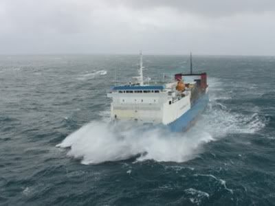
Muirneag's Darkest Hours
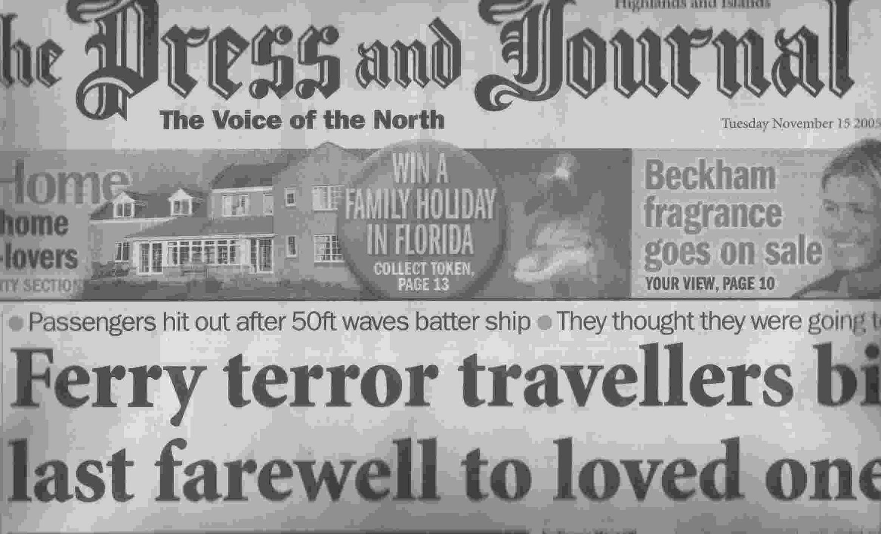
The Press and Journal - 15/11/05
Passengers hit out after 50ft waves batter ship
They thought they were going to die
By Fergus MacNeill
Terrified passengers on a storm-tossed ferry to the Western Isles were in such fear for their lives they wrote farewell notes to their loved ones. Now two agencies and the vessel operators are investigating why the MV Muirneag set sail from Ullapool across the Minch to Stornoway when, according to the Met Office, severe gales with 80 mph winds were
forecast by its Aberdeen staff. But the ferry operators yesterday defended Captain Alan Smith's decision to sail on Friday, saying the weather took the crew by surprise and was not forecast to arrive until lateer. The storm hit the Muirneag when she was about 2 hours into what should have been a 4 hour crossing. But it was more than 17 storm-lashed hours later that the ferry struggled into Stornoway Harbour at 3.30 a.m., after being pounded by 50 ft waves. At one point, the ferry ended up 18 miles north of the Butt of Lewis in the Atlantic, as Capt Smith desperately tried to outrun the storm. Passengers say he attempted to turn the vessel into the storm 15 times to reach Stornoway. Cars and lorries were damaged on the lurching vessel. Steven Collins, 22 of Bragar (Lewis) was rescued by Stornoway Coastguard helicopter after suffering concussion when he was flung to the deck. Angry passengers criticised the skipper and ferry operator Caledonian MacBrayne for allowing the vessel to sail.
Kenny Smith, from Arnol, said: "I started writing a farewell letter to my wife and children. I thought I was dead and would never see themagain. It was madness to sail with that storm coming". Paul Collins criticised CalMac after his 1961 classic Rover car was destroyed. He said: "Lives were put at risk. I'venever been so terrified in my entire life. That boat was in serious trouble - I really believe we were going to die. The captain tried over 15 times to turn the ship and failed. It was ignorant and arrogant of CalMac to allow that ship to leave Ullapool."
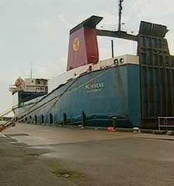
The Muirneag was on charter to CalMac from Glasgow-based Harrisons Clyde and carries mostly road haulage vehicles daily across the Minch. Yesterday the Marine Accidents Investigations Branch MAIB and the Maritime and Coastguard Agency MCA were investigating the voyage. CalMac now faces paying thousands of pounds compensation for the damaged vehicles. Container units owned by MacAskill Haulage were thrown off supporting trestles while two units crushed another belonging to D.R. MacLeod and cargoes of fish-farm food were flung to the deck. Philip Preston, operations manager at CalMac, said the captain was completely taken by surprise by the storm and tried to find safety by heading north and outrunning it. He said: "The vessel sailed from Ullapool at 10.15 a.m. and was expected in Stornoway at about 2.30 pm. The bad weather forecast was supposed to be coming through later in the afternoon, and it hit them completely out of the blue. The vessel had no option but to run ahead of it, heading north. I would not criticise the master, he did well to get the ship in eventually. We will co-operate with any outside agencies. We are assessing the damage at the moment and are speaking to our insurers.
Last night the Met Office said they had issued their first storm warning for the
Minch at 3 am on Friday, valid from 10am to 11pm, forecasting severe gales gusting to 80 mph. MCA spokesman Mark Clark said: "What we are looking at is how those vehicles on board the ferry were lashed to the deck, and what caused the slippage of the cargo. If you get slippage, this does affect the stability of the craft. London-based David Stewart, spokesman for the MAIB said: "We are talking to the operators and the owners and it may, or may not, go to a further investigation. We will know that in the next week or so."
Yesterday, the Muirneag failed to sail from Stornoway because of badweather, but many lorry drivers refused to go on board in any case after their ordeal. Some food was scarce in island shops as a result of the weather disrupting ferries.
The Isle of Lewis sailed empty from Stornoway on Sunday with recurring engine problems. She missed sailings last week after her main engine broke down. She was repaired briefly for a voyage across the Minch, but it took her 12 hours. Her replacement, the
Clansman, was weatherbound in Loch Broom all day, but ventured out after 5pm. She was due to arrive in Stornoway after 8pm.
Husband's poignant letter to his wife and children
Kenny Smith wrote a poignant farewell letter to his wife Carron and children - Kieran (5), Jack (3) and Kenny (nearly 2). The couple were married 3 months ago and are expecting a baby next year. With tears splashing onto the paper, he wrote:
"Dear Carron,
I love you so much. These are the last words I'll ever say to you. I will never see you again. I don't know what will happen tonight, but I will not live to the end of the night. Our time together was precious to me. I love you and the kids. You all mean the world to me. I would not have changed anything for the world. I am sorry I cannot be with you any more. Our life together was so complete. Our wedding was the best day of my life.
I will always love you and will cherish you forever - Kenny
The troubled journey of MV Muirneag on 11 November 2005 - an hour by hour account by its passengers
10.10 Leave Ullapool
12.00 Approaching Lewis. Crew and passengers have lunch. Extremely rough seas. Passengers surprised tosee MV Muirneag heading north up the Minch, passing the ferry Isle of Lewis, which is hugging the Lewis coastline.
16.00 Passengers kept in the dark. Alarmed when they spot the Butt of Lewis lighthouse, 25 miles from port. Passengers were never told they were heading so far north.
17.00 Damage begins. Lorries smash on lower deck. Oilspill makes deck hazardous. Passengers anxious and are told ship is turning back. Instead, she continues 30 miles further into the North Atlantic.
18.00 Impossible to turn back in hurricane, despite numerous attempts. Loud bangs below. Lorries screeching as they lurch in heavy seas. One trailer hits steps. Container units collapse.
21.00 Ship pitching and rolling in high waves. Vehicles constantly scraping and moving. Passengers emotional and frightened. Steering very difficult. Unable to turn south against sea. Passengers grip on to furniture and each other.
22.00 Cars sliding on greasy deck. Loud noises below accentuate fears. Two passengers have showdown with captain on bridge. Demand information.
22.15 Hurricane winds. Steven Collins flung out of seat by violent force of rolling ship. Smacks his head against wall and crashes with a fellow driver. Driver falls under table and gashes leg. No crew to administer first aid. Struggles below to retrieve bandages from his lorry. People afraid.
23.00 Eighty mph winds. Fearful passengers make "final" calls to loved ones. Emotions heightened after mobile phone batteries lose power. Some write farewell letters to family. Noise and damage below continues.
(Saturday morning)
01.30 Casualty suffers concussion and is airlifted off in heavy seas. 18 miles out in the Atlantic. Winchman warned of rolling car on deck. Seaman caught by winchrope, saved by winchman.
02.00 Passegners scared, angry and emotional. Want captain to shelter in Broad Bay in lee of land. Vessel finally turns south after about 20 attempts
04.00 Fights heavy seas to enter Stornoway Harbour
05.00 Drivers ordered to leave vehicles.
Ferry cancellations
BERNERAY TO LEVERBURGH
Due to adverse weather 1355ex Berneray + 1505ex Leverburgh have been cancelled. Next sailing 0830ex Berneray 12/11, weather permitting.
LARGS CUMBRAE SERVICE
DUE TO SEVERE WEATHER CONDITIONS THE LARGS CUMBRAE SERVICE HAS BEEN CANCELLED UNTILL FURTHER NOTICE.LAST SAILING WAS THE 10.15 DEPARTING LARGS.
Rothesay/Wemyss Bay Service
Due to adverse weather conditions the following sailings have been cancelled 1100 & 1145 ex Rothesay & 1015 1100 & 1215 Ex Wemyss Bay. MV Bute will depart Gourock @ 1200 sailing to Rothesay. Intending passengers are advised to check prior to travelling.
Brodick/Ardrossan Service
Due to adverse weather conditions passengers are advised that the 1105 ex Brodick will be going to Gourock. ETA 1310hours. There will be a bus service from Ardrossan to Gourock at 1230hours. We apologise for any inconvenience this may cause.
Uig / Lochmaddy Service Disruption 11/11/05
Due to adverse weather conditions the 1245 ex Lochmaddy and the 1500 ex Uig sailings are cancelled. Subject to an improvement in weather conditions, MV Hebrides hopes to take up the 0730 sailing ex Lochmaddy on Saturday 12/11/05.
Services to Colonsay, Barra, Uist and Mull
Due to adverse weather conditions the following sailings have been affected:---- 0930 sailing to Barra & Uist cancelled. Next sailing 1500 Sunday 13th as per timetable.---- 1000 sailing to Colonsay cancelled. Next sailing 1430 Saturday 12th weather permitting.--- 1600, 1700 and 2130 Oban/Craignure/Oban sailings currently looking uncertain due to weather. A final decision will be made at 1500. MV Isle of Mull will however operate an extra Oban - Craignure sailing today at 1200 weather permitting.
Sound of Barra Service
The 09:25hrs ex Ardmhor and the return 10:30hrs ex Eriskay have now been cancelled. Due to the weather forecast the remaining sailings for today are very doubtful.
Mallaig-Small Isles service
The service to the Small Isles today of Eigg and Muck has been cancelled due to adverse weather.
Mallaig - Armadale Service
The 0840 ex Mallaig and the 0925 ex Armadale have been cancelled due to adverse weather. We will update later with regard to this afternoons sailings.
Fionnphort-Iona service
Due to adverse weatherconditions this service is off at present. We will update as and when we get further information. This service has been CANCELLED for the rest of the day.
Tayinloan - Gigha Service
Due to adverse weather conditions the Gigha Service has been suspended until further notice.
SOUND of BARRA SERVICE
CHARGEHAND HAS NOW CANCELLED THE 12:30hrs EX ARDMHOR AND THE RETURN 14:10hrs EX ERISKAY. ALSO THE 17:10hrs AND THE RETURN 18:15hrs EX ERISKAY HAVE BEEN CANCELLED. THUS THERE HAVE BEEN NO SAILINGS ONB THIS SERVICE TODAY